|
Way back in the murky past of 2002 I was in the aftermath of my exams and we had just won the fight to continue the already rare Archaeology AS (half-A level) course all the way through to a complete A level qualification. To celebrate, our archaeology lecturer had a great idea. We would build a roundhouse. A typical Iron Age (c.500BC-332BC) dwelling made of wooden posts, wattle and daub walls and a thatched roof. So, for 2 days a week we were traipsed from our college campus in Marple, to the Iron Age Hillfort just up the hill at Mellor, (a site that I also happened to be working on as a volunteer archaeologist – my first ever dig!) It was fun, it was exciting, it was subject to planning permission….
Our roundhouse was to be 1/3 size of a real one, the worry was that we may not have the time to complete construction of a full one. Logs, willow and hazel rods arrived and spades were issued. The first task was marking out, digging holes for the posts and chopping the wood. I have no idea whose idea it was to let teenage boys loose with an axe, but it seemed to work (barring one bloody finger incident). The posts were shaped to points in order to make pushing them into the ground easier and we packed dirt and stones back in around the posts to hold them in place. 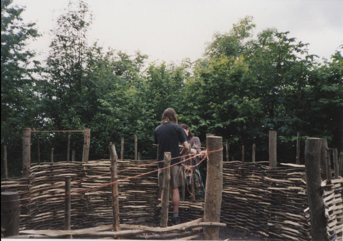
Building the walls
To do the roof we cheated a bit, Greater Manchester is not known for its reed beds and thatch cultivation, a real roundhouse up here is likely to have had a turf roof. But we were after new skills and a professional Thatcher from Norfolk came up to show us how to make the roof. First, like with the walls we needed sturdy logs to create a cone shape. Then it was back to the hazel and willow rods to create the horizontal bars that would be the framework for the thatch. The thatch was split into sheaves and our friendly pro showed us how to sew the thatch onto the roof with a huge wooden needle, and how to bash it into shape with, what looked like a giant wooden spaghetti spoon. He got us started and we did the rest, until we got to the top where it was a bit more complicated. More willow was prodded between the thatch to create ventilation and the thatch was brought to a point. No oculus style hole in the roof for us, they have the unfortunate side effect of creating a wind funnel and dragging any hearth fire up into the thatch and burning down the roundhouse. Not that we were allowed to have a fire in there anyway, at a 1/3 size, even lighting a match in there would probably have burned it down.
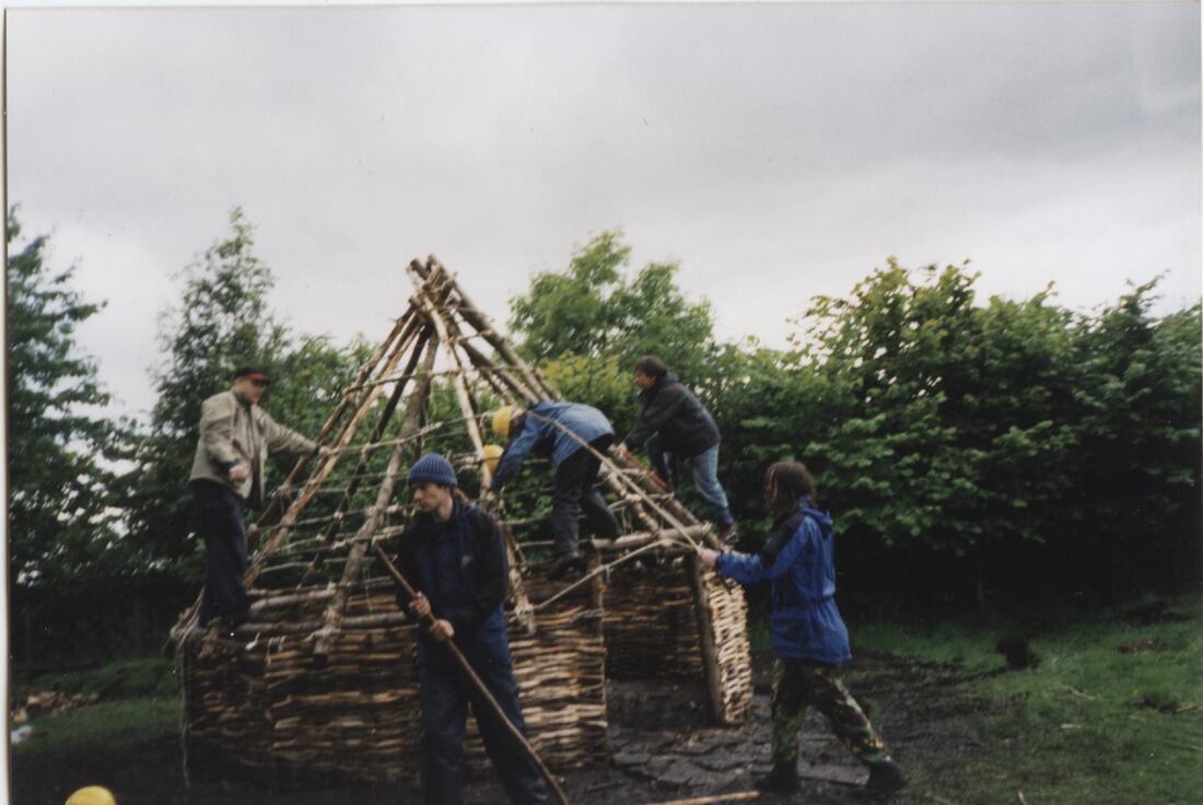
Creating a framework for the roof
Once the roof was done we got a first-hand experience of why ring ditches exist around round houses. Going up to the site after and during a rain storm showed just how effective the thatch was, at keeping the inside bone dry sure, but also at flooding the surrounding ground. So, we dug a ring ditch, no one wants rotten foundations to their roundhouse.
So, the walls were built, the roof was on the drainage ditch was dug, with spare logs laft over to create a little bridge to the doorway. There’s no archaeological evidence for these that we know of, most excavated ring ditches tend to terminate and leave a space for the entranceway, but ours kept flooding so we dug the ditch over the entrance and gave it a bridge. Then dug an offshoot into the woodland and the side of the hill when it still flooded! Drainage sorted out it was time for the real fun stuff. Daubing the walls! Though there were some caveats, being the modern age and all, and health and safety being what it was, we were not allowed to use animal manure to make our daub, (but we could play with sharp axes and stand 7ft in the air on flimsy willow rods). So, the daub was unhistorically accurate clay and chopped up bits of thatch, which we smeared unenthusiastically on the walls and watched it crack and plop into the ditch. It was not at all sticky. What to do? DIRT FIGHT! Well, we were teenagers. 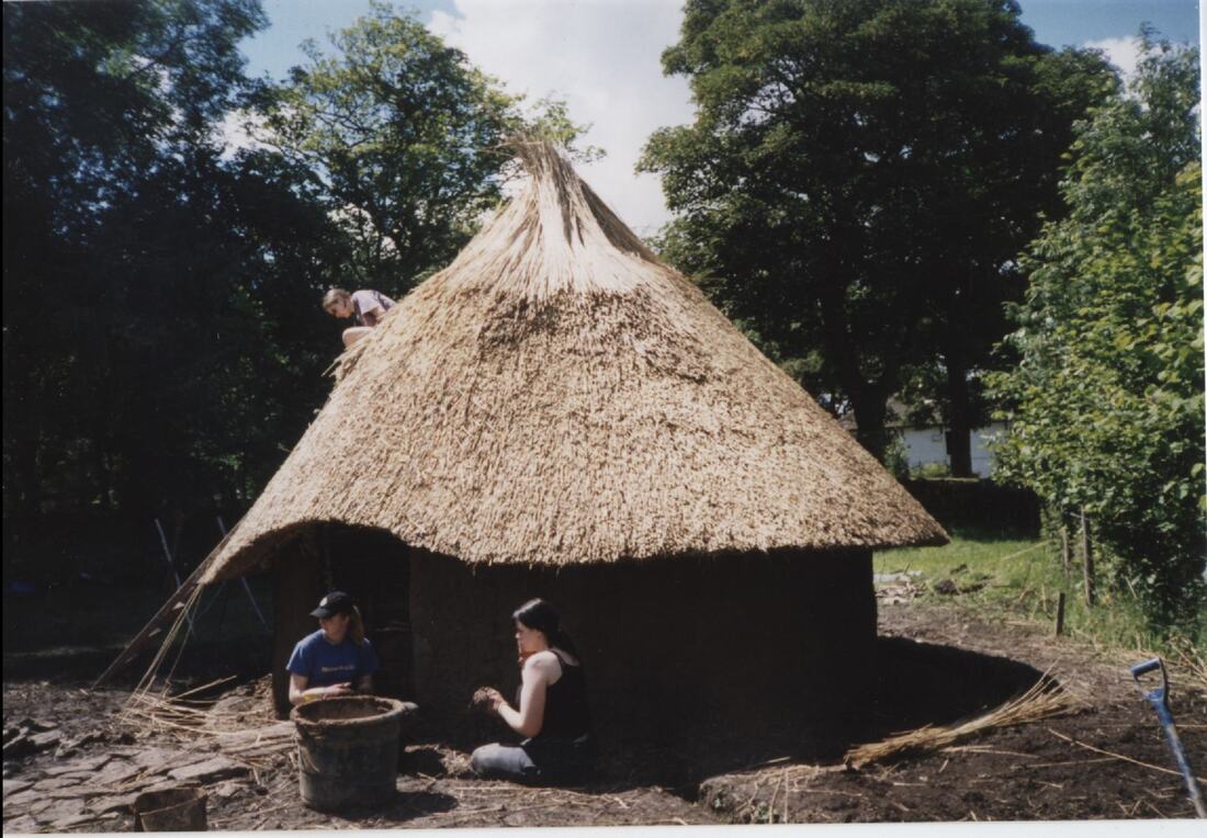
Almost there: Fun with thatch and daub
Anyhow the roundhouse got splattered as we lobbed dirt at each other and this was the solution. Lob the makeshift daub at the wattlework. In this way the clay, chopped thatch and grass mix actually worked its way in between the willow and hazel rods creating something sticky within the wall that we could build on. So, several days were spent hurling soggy wet clay at the walls. One enterprising student came up with an experiment one day. Her family cat had been to the groomers, and being a rather fluffy animal, our friend was now in possession of a full carrier bag of cat fur to add to the daub mix. It worked really well, we used the clay and cat fur mix to daub around the doorway and for years this remained the smoothest and best-looking bit of all the daubing. So, there you go, tip for the apocalypse and building your stick house, cat fur is a good bonding agent if you want a smooth finish.
Overall, we spent 6 weeks doing this, 12 days in total, which for students wholly unskilled in the art of roundhouse creation, is not bad at all. Imagine how fast these things could have gone up when being built by people who actually knew what they were doing? To celebrate on our final day we built a fire and boiled up a stew in a replica Iron Age cooking pot, which was very welcome on a wet and miserable day! We also cooked authentic Iron Age, Linda McCartney Veggie Sausages on a fire (apparently you can’t undercook them!). We were sat enjoying our Iron Age feast complete with authentic Iron Age bread when some official looking fellow came up to ‘assess the building for council tax’! Some of us always intended to sleep over in the house, especially during excavation season but I don’t think anyone ever successfully managed it, the place was pretty draughty, though it was always dry and was certainly a favourite place for the dig team to skive off on wet excavation days. 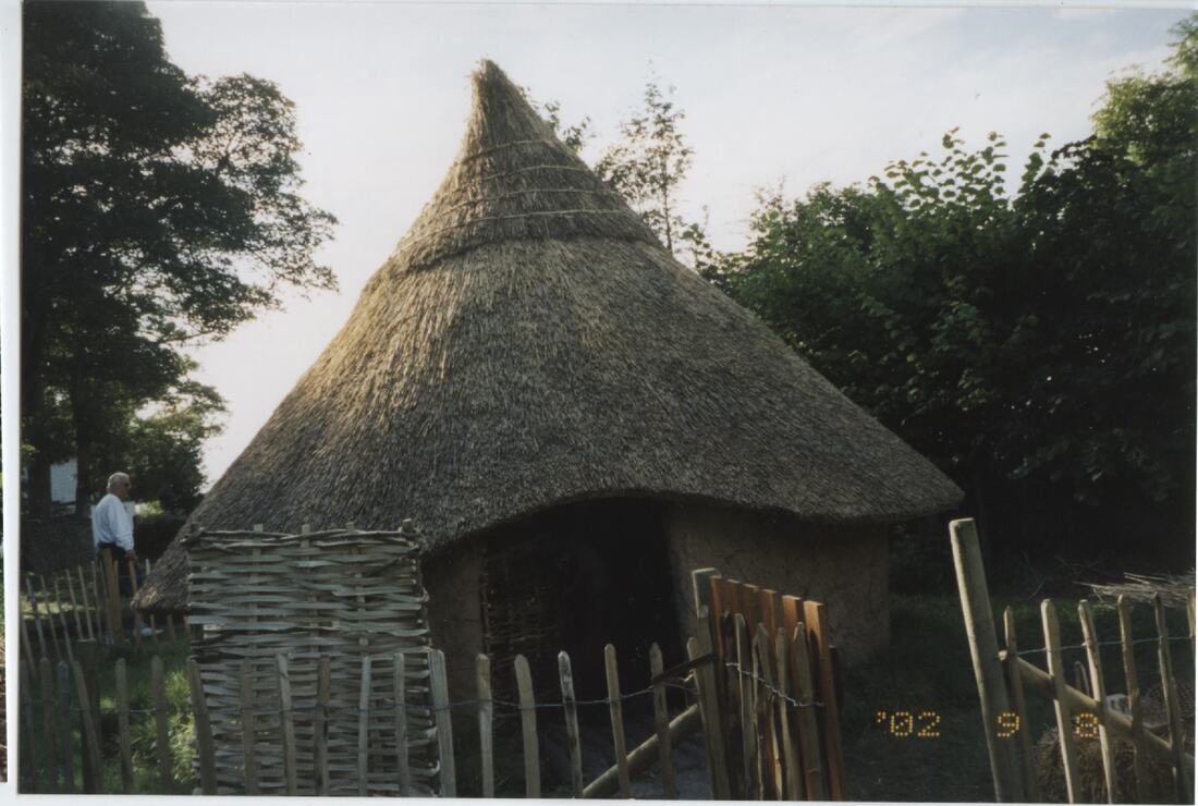
Our completed roundhouse - I'm still ridiculously proud of it! This was how it looked on our final day
The roundhouse is still there to this day, although the college no longer re-daub the walls and tidy it up like they used to. About 10 years ago or so I heard that the drip gully had been filled in due to health and safety concerns. The roof was collapsing a little the last time that I saw it but that must be several years ago now … perhaps I should head back for one last look before it falls in completely.
It was an unforgettable time and fuelled my passion for archaeology as well as allowing me to see what happens when you trust teenagers with sharp tools. – For anyone who has read my books, let me tell you, a lot of Jerry is based on several characters building that roundhouse. It was certainly some of the most fun I’ve had on site and I loved explaining how we did it to visitors on Mellor open days. I would love the chance to do something similar again does anyone know if channel 4 would be up for a new experimental archaeology show? Though I’m still not sure about being trusted with an axe! 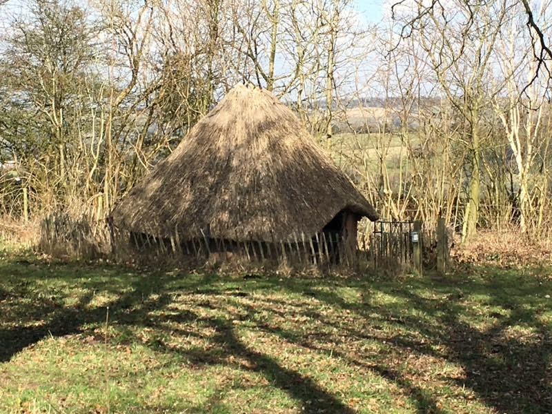
The roundhouse as it looked in 2018 - still standing but definitely a little worse for wear.
1 Comment
So far in our journey through the murky world of commercial archaeology we have looked at:
This time I’m looking at what happens if we have a lot of archaeology, the sort of thing that happens when our geophysical survey looks noisy and our evaluation confirmed the presence of a lot of features. This is when we strip larger areas. These can vary in size from a few square meters to several hectares and are either targeted at specific ‘hot spots’ identified by the geophysical survey and evaluation, or cover the whole site. 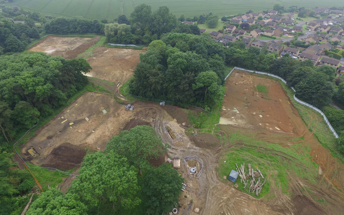
This is one site, spread over 4 distinct areas that I did a few years ago in Northamptonshire. - Image is from the MOLA blog
These are the sites that I really like doing. We are no longer peeking through the keyhole at the archaeology but exposing the whole area. There is a downside of course, excavation is a destructive process so a full open area excavation like this will leave very little behind. Though the development will remove anything that we do not. Our records will become the only information available on the site, so we have to do a thorough job. Sites can last anything from a few weeks to several months. My last two large-scale sites like this were both in Oxfordshire, one took us 24 weeks the other was 18 weeks. I did the first one nearly 2 years ago now and we are still trying to get the initial write up out, there was that much archaeology! Seriously – so much archaeology, you can see it on Google Maps!
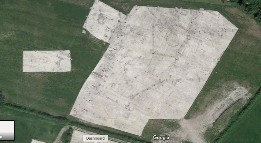
I can't tell you where this one is as I've not finished the write up, but it's visible on Google maps, just look at those ring ditches! - credit for the image is of course Google.
Large scale stripped areas like this give us a lot to look at, we could have a whole settlement with several roundhouses, or we could be looking at ditches as part of a network of fields. We may also come across unknown burial grounds or urn fields all of which can give us a really good idea of what the type of site is that we are looking at, e.g.: domestic, agricultural, ritual etc.
The large open excavations like this are the very last chance that we get to look at the archaeology ahead of any development, in fact it is the last time anyone will be able to see the archaeology in this area as the development will remove almost everything in the area. We must be careful with our records then. Although it may come as a surprise to some that we do not actually excavate everything, instead we ‘sample’ the features. We also remove the topsoil and overburden by machine, although this is often scanned with a metal detector prior to removal, but any features or finds that were contained within this material are generally lost on a commercial site as we simply are not allocated the time available in order to undertake a thorough search of these layers. In such cases, an organised metal detector survey before the archaeological works commence would be useful as they would be able to collect and log any metal finds in the layers that will be stripped away. It is the same with the archaeology itself. A ditch for instance may cross the site and be 150 meters long and 1.5 meters wide. We will not excavate the whole ditch, rather we usually excavate a 10% sample of the feature. Generally this means excavating slots 1 meter wide at 10-meter intervals along the length of the ditch, although we will be sure to excavate any corners, terminal ends and any place where the ditch crosses another feature as this can tell us which feature is earlier and from that we can extrapolate how the landscape use changed. However, this does mean that 90% of that ditch remains unexcavated when the machines come in to develop the site. It is unfortunate, we could lose a lot in that 90%. Large pits too are generally only excavated as 50% so that we have a section showing us the layers filling the pit, but unless we have a very good reason to excavate the other half then our 50% sample is all we take. Postholes are smaller and are often fully excavated, Likewise, features like burials and cremations are always fully excavated. Special features such as ring ditches are generally excavated to a 50% quota generally as 1-meter slots with 1 meter gaps between. They look very good when they are done. 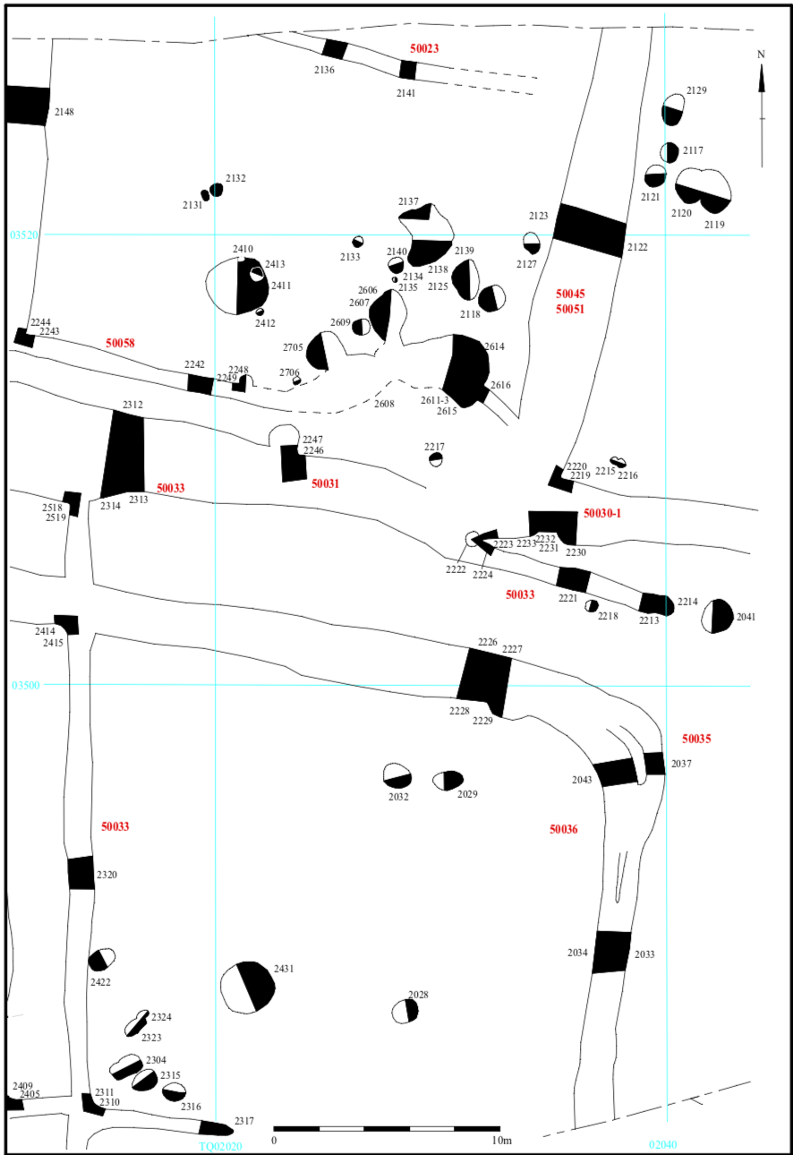
Part of a site plan for the first major multiphase site I ever ran, in Littlehampton. - Image from TVAS
It would be nice to be able to excavate sites 100%, but unfortunately it looks likely that we may be curbed even more as the government try to cut the ‘red tape’ as part of the shake-up of planning and development. We are already painfully aware of how much we lose under our current conditions, any curtailing to our ability to examine sites prior to development will lead to a huge loss of archaeological information. Many of us are in the process of writing to our MPs in order to ensure that our heritage is protected and point out that developers tend to sit on the sites for 10 years and call us in at the last minute – hence they feel we delay them, but this is another argument for another day, back to today’s discussion, open area excavations.
The main reason I love these sites is that it feels like we can really start to answer the questions about what was happening there in the past, we can start to see different phases of activity. On my last open excavation like this we had Iron Age activity all around the south and central areas of the site, but the Roman material was heavily concentrated to the north showing that people were using the area differently in these periods. We can start considering landscape use and the movement of people through the landscape. These long excavations are fun because we really feel like we are beginning to understand the past use of the site. We generate a lot of paperwork on these projects and it can be tough work, but there always tends to be a good atmosphere and the feeling that these are the jobs that people are really here for. It is these sites where we often find the most interesting archaeology, to name a few: Must Farm, the Viking Mass Grave in Oxfordshire, the Amesbury Archer, the Prittlewell burial and the North Berstead Warrior, but there are also Roman farmsteads, medieval brew houses and many many more. 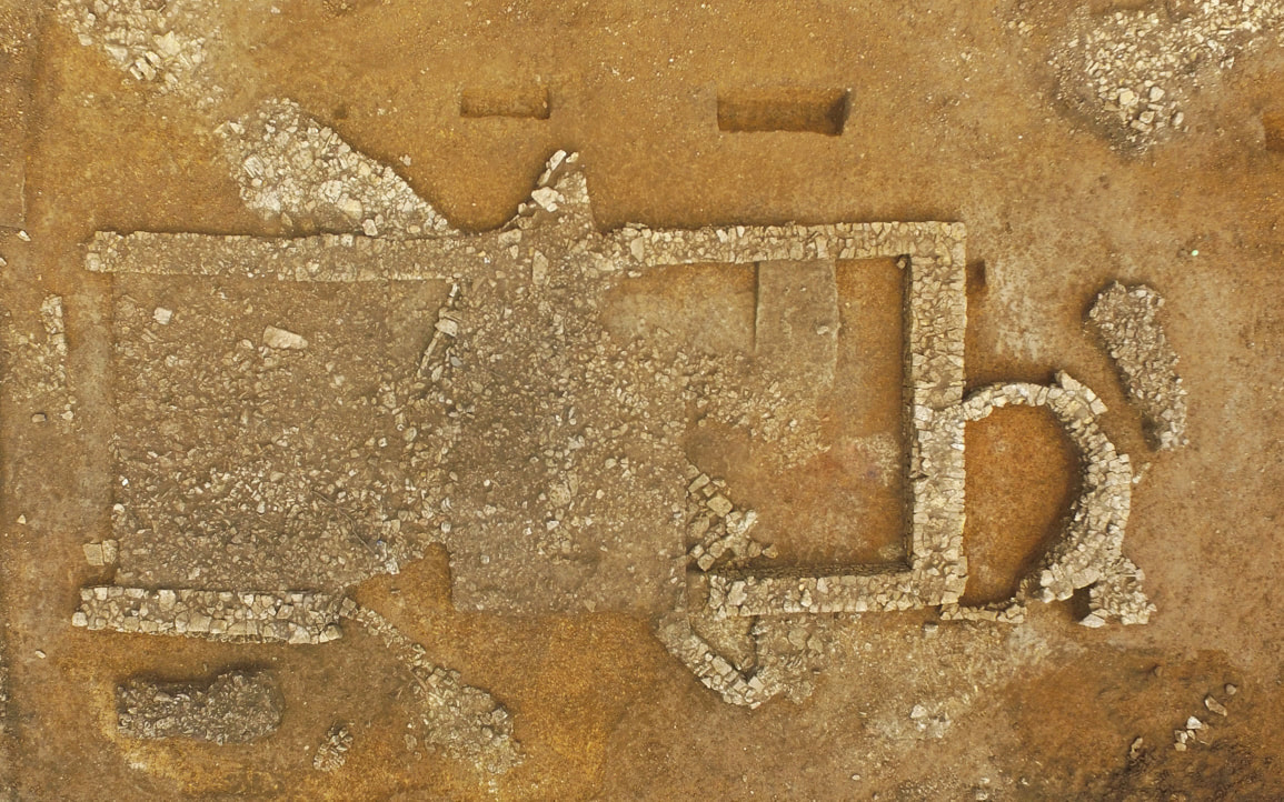
A medieval brew house lying above Roman walls, the evaluation trenches missed this and it came as quite a surprise when we found it. - Image is from the MOLA blog

In a change to my originally intended blog post on open area excavations (see next month for that) I thought I would detail my experience as a commercial archaeologist during the Covid-19 lockdown. During the lockdown, most folks have been stuck inside, isolated from friends and family, working from home or furloughed unless in vitally important (key worker) roles such as hospital, food factory or supermarket workers. Things in construction happened differently; that is to say, nothing really changed. So, as a non-key worker who continued to work on site with and around others, here is an example of how we managed good practice (or did the best we could to stay safe whilst having to work). I work for a small satellite office of one of the bigger archaeological companies – I’m not naming names but you can probably figure out which one without too much effort. Back in March we could see the virus looming on the horizon and I had a lot of post-ex work to do so about a week before lockdown started I packed up all my files and my work laptop and took all my gear home (managing one cheeky motorbike ride before I did). So, when lockdown actually happened I had already been working at home (and cursing IT) for about a week, so the immediate lockdown didn’t change much for me. Our first official orders were that everyone out on site was pulled in immediately, so everyone was at home for at least a week, then those who were finishing off sites headed out for a few days under strict conditions to tidy up and make sites safe. I did two weeks of working on my post-ex at home before I was called on to head back out to site. You see the country was on lockdown, pubs closed, shops closed, businesses closed, but not construction. HS2 – the major UK rail infrastructure project, never shut down (to the best of my knowledge), nor did some of the large development sites (although some did shut down and to them I’m sure a lot of archaeologists and other workers are grateful). Our problem is that if construction doesn’t stop, we as archaeologists can’t stop as we have to clear and record the site either before or during work (see my previous commercial archaeology 101 blog entries for details on how it all works). If we don’t, either the development is stopped or, (more likely), they continue anyway, and we lose the archaeology forever.  Well how else are you supposed to do site work at home? Now I will hold my hands up and admit I was lucky with the site I was sent to – others have not had the same generally positive experience that I have so I’ll stress again that this was my experience. I was sent to a watching brief, so I was the only archaeologist on site performing observations on trenches being excavated for a new thermal water heating system, (or something of the like) in the grounds of a stately home. My job was immediately made much easier by the fact that there were no longer tourists in the grounds of said stately home. The site access was heavily controlled with only specified people allowed to operate the gate. There was ample parking (I was using my own vehicle and keeping it clean), with plenty of space and there was a maximum of eight on site, although more regularly five and of these I was only regularly working with three. So, we had a small closed group of people and plenty of space. The 2m rule was instigated at all times and we had separate welfare – theirs was a cabin, mine was my car and the public toilets in the ground of the stately home (these were opened exclusively for me). I had my own bottle of hand sanitiser, disinfectant and soap provided by the office, and a shiny new set of COVID-19 RAMS, (Risk Assessment and Method Statement), alongside my normal RAMS and two daily briefing sheets to be filled in and copied to our office H&S officer every day (more paperwork, YAY). The COVID-19 daily brief was to ensure that my facilities were clean, we could maintain distance, no one on-site was ill, my vehicle was clean and disinfected, that no one besides me had used my tools, and a few other things. From this point we managed to carry on as a fairly normal watching brief, the guys dug the trench, I kept an eyeball out for interesting stuff, (there were brick culverts. Lots and lots of brick culverts) so I was kept busy. I cannot praise my groundworkers enough, these guys were great. They asked what I was looking for and got really good at spotting the changes in geology and cleaning brickwork, and at all times they were brilliant at keeping at least 2m apart and moving their kit out of the way, letting me move my kit and giving me the time and space that I needed to undertake archaeological recording. In fact, as the site is completed I can probably do a name drop. Leggate Plant, thanks lads! You know who you are, thank you for making me feel safe in these strange times! 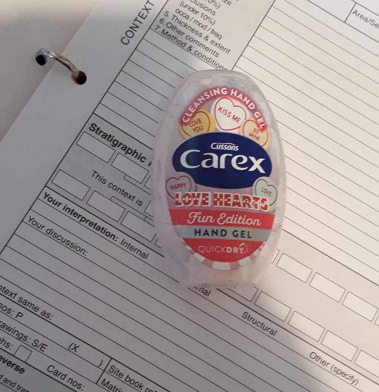 Very professional I am, Love Hearts hand sanitizer. It was the only thing left and I used all of it! So, I was quite content actually going out to site in the middle of a pandemic as my H&S was really good and those I was with were really good too. We had one incident about three and a half weeks into the job when one of the pipe laying guys (not the team I was working with, these guys were following us up the pipe about a week behind so I didn’t know anyone besides their supervisor) turned up and within minutes told the site manager that he was running a fever and had a nasty cough. The site manager (rightly) gave him one hell of a telling off and sent him to go sit in the car whilst he called his managers for advice and got the lads to give the cabin a thorough scrub whilst increasing site distance for the day to 3m. The site was stood down for the following day (lucky as it rained like hell that day) and we returned the day after. It later turned out that this guy was just hungover and was not sick with COVID-19 but how were we to know? Our only real problem with working together was that keeping a 2m distance from everyone on site is A) much more stressful than it sounds and b) easy to forget after a few days when auto-pilot brain wants to take over. We all got very good at reminding each other and making a real point of standing there saying ‘that ain’t 2 meters that’s 1.9,’ or ‘3 meters, bit anti-social today ain’t you?’ (we can still have some fun, sometimes making light of the situation is the best way). All in all then my site experience so far has been quite good, but, I only had to be responsible for myself. Heading up a larger site will be much more of a challenge. Now my team are mostly sensible, and they are taking this seriously, but even the best laid plans can go wrong. Humans naturally gravitate towards one another when talking and before you know it you can be stood right beside the person you are taking to. Or maybe we need to lift something heavy like a cremation urn. There is no way of keeping a 2m distance and doing that. And sure we can all have our own shovel, but we only have one site camera and one GPS unit, and one site file, into which all the completed records go, so there will be multiple people touching certain objects – this is something that we can’t change quickly. Though we can disinfect stuff. But what about even larger sites, development sites with 100’s of people. There is a hashtag on twitter #shutthesites that has been highlighting the cramped cafeteria’s and busy sites throughout the pandemic and there have been a lot of construction workers who have been afraid to go to work with good reason. Some of my collages have reported terrible site conditions on development sites where they have arrived at packed car parks, there’s been no social distancing on site at all until they reach the archaeological area when they can breathe a bit and it’s just them, but even with staggered break times they cannot use the cafeteria or welfare as there are simply too many on site for it to be safe. Fortunately, all our work at the moment is voluntary, so we are not being forced back on site. Although, as government legislation changes by the day, who knows how long that will last. It would be interesting to hear more experiences of archaeology in lockdown whether on site, working at home or on furlough – please do feel free to share your experiences in the comments below or on Facebook and stay safe on your sites. In my blog travels through commercial archaeology so far, we have: undertaken a Desk-Based Assessment, marched through the field undertaking a Geophysical survey and opened up a few Archaeological Trial Trenches as part of an evaluation. And, what did we find? Well for the purposes of today’s blog post, not a lot. If our evaluation turned up mostly blank trenches, but did have a few scattered dated features, then we do still have an archaeological interest in the site. It is at this point that we will undertake an archaeological watching brief. In this case we observe any groundworks pertaining to the new development. The development itself having been assessed as likely to cause minimal damage (if that) to the limited archaeological remains on the site. Alternately we may be in an area of known heritage, say a scheduled monument or stately home with a considerable amount of suspected archaeological remains. In these cases, full-scale excavation is undesirable and an archaeological watching brief is preferred as it is the least destructive means of obtaining information about the monument or property, allowing for the preservation of remains outside of the development footprint without disturbance (in-situ). 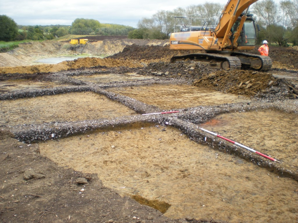 I'm proud of this one - My first published site a huge burnt mound found during a watching brief, note the huge lake and the lurking machine ready to take it all away The watching brief then is the final part (with the exception of the report) of archaeological work that we will undertake on a site with limited archaeological potential. We are generally expecting very little (except for the scheduled monument scenario outlined above), and record everything we see for posterity, so that it can be referenced should any other work take place in the area. In general we see a lot less than we would on an evaluation and considerably less than on a targeted excavation or an open area. Like the evaluation, what we are gaining is a snapshot of the site, but unlike the evaluation, what we see on a watching brief is being removed as we watch, our watching brief record will be the only record that the feature ever existed. Unless as on my current site we have something like a wall or culvert that the new pipe can be routed beneath. It is not a fool proof method, and the archaeological observations can be sporadic, meaning that several people may have done a site visit, which can also cause nightmares for the one who ends up writing the report. But it is important to note that even finding nothing at all can be important for future research in the area, to quote that famous phrase – absence of evidence is not necessarily evidence of absence, and noting that nothing of archaeological interest was found in one field whilst three roundhouses were found in another can bring us closer to understanding the wider landscape of an area. In my experience the watching brief is the least liked task of the field archaeologist (site dependent) as we actually have very little chance to really analyse what we are looking at. It is important to note that the watching brief is actually a very versatile form of site investigation and can range from an afternoon spent observing the excavation of footings for a new conservatory, to several weeks of sporadic trips observing the creation of a new road, to the several weeks of stripping small areas (the footprint) of the buildings of a small development, however this latter example borders on targeted excavation and open area which I will discuss next time.  I'm never quite sure exactly what I'm expected to see when I'm sent out to check boreholes - though in this one we can actually see some stratigraphy! In general, an archaeological watching brief is about observation. The archaeologist is not running the site (unlike an evaluation or excavation), we are just there to observe the groundworks involved with the construction. This can make the process incredibly frustrating for both parties – the developer wants to get on with the job and the archaeologist wants to record everything as accurately as possible. Occasionally there can be friction. This is not always true: some groundworkers and developers are actually great to work with. For example, the current team that I am working with, under the challenging conditions of Covid-19 and social distancing, are actually some of the best lads I have worked with on a site. We manage to give each other space whilst maintaining our observations and when we come across yet another post-medieval brick drain or foundation wall, they pause the machine and jump in with shovels to clear all the debris around the wall so that I can then hop in with my gear whilst they have a break, and do my final cleaning, photos, section drawings, scaled plan and measured tie-ins from established structures or grid points and record my contexts sheets. This can take anything from 10 minutes to the 3.5 hours I spent recording a monstrous intersection of several walls on Wednesday morning. These guys have been great and a real pleasure to work with, and I wish I could yell their company name from the rooftops, but I’m bound by Client and site confidentiality until the job is all done.  An old wall caught in a narrow trench - due to the nature of the watching brief this is everything of it that we see, no chasing it to see what it's part of - though an old plan of the area may help. Other times watching briefs can be a real pain, as the archaeologist is not in charge of the site we cannot realistically halt the operation, however we are supposed to be given enough time to make our records and observations. Minutes can often be enough to make basic records, but often full recording is challenging, as the machine crunches on relentlessly and we are left playing catch up and recording features that may once have been ditches or pits in the section of the trench. Hopefully we will have managed to see the shape of the feature on the ground and thus determine whether it was a circular pit or a linear ditch. Although this can be deceptive – I recall vividly recording something that I and everyone else on site swore was a ditch in an evaluation, only to find when we returned and stripped the whole site that it was a very, very big pit and not the potential early medieval boundary to Bury St. Edmunds. And, there may be another problem, (now this could just be me, but I suspect not), sometimes we simply are not listened to. On one of the worst sites I ever had the pleasure of doing a watching brief on, I found myself having to phone my (male) manager to have him explain that yes I was qualified to do this job, yes all those qualification cards in my wallet (CSCS, Cat and Genny, Overhead cables, manual handling, vehicle marshalling, my company ID card and several others) were really mine and yes I had earned them despite the desperately unfortunate handicap of being a woman! I had to phone my manager several times that day and indeed that week to have him repeat to the site foreman word for word, what I had said I was doing/ needed to do and why. This guy was a nightmare, and (being stubborn) I refused to swap the site with one of my male counterparts because by this point I was annoyed – I’d also lodged a formal complaint and wanted to see how it panned out, so this nightmare continued for about 2 weeks, whilst I recorded the, actually fairly substantial amount of pre-historic activity in the area of a new small two-house development. (I did actually get a very grudging apology – that was in no way sincere at the end of the job, but I also found out later that he also complained that a woman (me) had written the site report too). Fortunately, there seem to be less and less of these “gentlemen” around, but unfortunately construction is still rather male dominated – come on Ladies I want to see more female plant operators and site forewomen! Usually, once a difficult Forman realises that I do actually know what I’m doing and that I’m not trying to hold them up, but am willing to work with them to keep the site moving (so far as is reasonable), they usually relent and let me get on unhindered.  And sometimes we look at holes inside buildings too - Again, there is not much information to be gleaned from a hole this size but we may see something. Anecdotes aside, the archaeological watching brief is a short observational analysis of a site. It is not something we would usually do in an area where lots of archaeological remains were expected – unless it is a significant site and the activity is minimal, such as a new pipeline for example. As a result, the ground interventions that we are looking at are generally half a metre wide and a metre or so deep (depending on the pipe, footing etc), so we only have a very small window to see what is going on. I once did a watching brief on the footings for a new garden centre, this involved 100 1m x1m squared excavated to a 1.5m depth and immediately filled with concrete. Fortunately, there was actually nothing to see, though I did manage to photograph every hole from all 4 angles just in case something showed up later. I’ve never found a major discovery during a watching brief and the chance of making one is very low because of the speed we have to go, but it is still possible and I would love to hear stories from other archaeologist who have made interesting discoveries during a watching brief! Next time I’ll be looking at my favourite type of site, the targeted or open area excavation; a strip, map and sample – this is where all the real fun happens.  Following on from my previous blog on geophysics and the preceding one on Desk-Based Assessments, this time I’m discussing one of the ways we can take the archaeological process forward following those processes. In this case: Archaeological Trial Trenching. It is important to note here that trenching is intended to give archaeologists as much of a view of the site as possible whilst causing the least damage, and that what we see is only a window into what lies below the ground. There is a distinct advantage therefore in evaluation trenching following a geophysical survey as we can use the survey results to identify potential archaeological hotspots, or individual features and so strategically target our trenches to assess the dates and nature of the expected archaeology, and test the accuracy of the geophysical survey. If there is no geophysical survey available, trenches are usually planned to be excavated either in a herringbone pattern across the site or alternating east-west / north-south to cover a specified percentage of the overall site area. Trenches can be any size and shape. Usually we mean something 1.80m wide by 10-50m in length, but a trench can be as small as a 1m x 1m hole (often referred to as a test pit). There is also no set number of trenches for an archaeological evaluation. The number and size of the trenches required is determined on a site by site basis. Smaller sites requiring between 1 and 10 trenches and larger ones anything from 30 -300 or more. 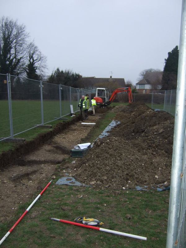 Busy archaeologists in a well fenced rural trench with small gullies in the foreground There is no set depth that we excavate trenches to either. We look for the archaeological horizons, so the uppermost layer of strata in which we encounter archaeological features, this also on a site by site basis; the archaeological horizon may be the upper level of the natural geological strata or it may be a demolition layer into which pits have been cut. Rural sites often produce shallow trenches usually 0.50m or less. (although deeper stratigraphic sequences may be seen at the base of hills or in heavily worked areas. By contrast urban sites produce trenches that are frequently over 1m in depth and can be several meters deep due to the use and reuse of the site over time. The aim of the archaeological evaluation trenching is to assess the archaeological potential and the expected significance of any archaeological deposits or features encountered. A large number of archeologically blank trenches indicates a low potential for previous activity to be present on the site. Likewise, a substantial amount of modern landscaping which has resulted in heavy disturbance of the underlying natural geology of the site will indicate a low potential for the survival of archaeological materials. However, trenches which produce archaeology can be indicative of moderate to high potential for previous land use and settlement in which case further archaeological works are likely to be requested before any proposed development of the land will be allowed to proceed. So, how is the evaluation conducted? Usually there will be at least two archaeologists present on an evaluation job. A field supervisor to monitor the machine and field archaeologists to undertake recording and excavation of the features. Archaeologists on site will work to a Written Scheme of Investigation (WSI) which details the intended development, known historical background of the area including any previous archaeological works, the expected geology (as noted in the British Geological Survey), height above Ordnance Datum, and if we are lucky, the service plans for the site detailing where any underground cables and/or service runs may be (these are frequently inaccurate see my previous services blog post!). We also have a plan of the intended trench locations. These days we usually load this data into a GPS unit and set out and record our trenches onto the machine. However, it is possible to both set out and record using tape measures and triangulation, although as use of the GPS becomes more frequent, this skill is being lost. The first thing the supervisor should do on arriving on site (besides greeting the client and if on an active construction site undertaking an induction) is to ensure that the site is safe to work on and that welfare is available (this may be arriving later or may be local facilities). The supervisor should also walk the site with the trench plan to look for hazards such as overhead cables, fences, trees or other potential issues that may require the repositioning of a trench or may cause a hazard to the staff working on the site. 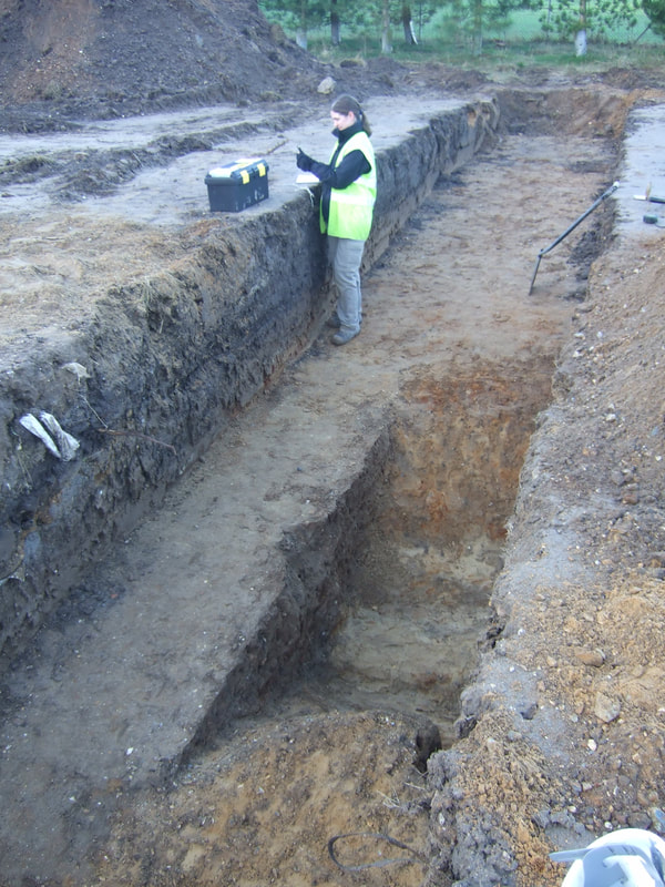 A deeper rural excavation: one of my early sites! Trenches can be laid out using a plan mapped onto a GPS or can be measured in from landmarks on a map. To ensure that the correct percentage of the site is covered by the evaluation trenching it is a good idea to extend each trench by 1 or 2 meters as some inevitably end up smaller. It’s also a good idea to dig a test pit in at least one trench to test that what looks like the right natural layer is really the layer we are looking for. Trenches are stripped by machine with a bladed bucket, affectionately referred to as the big yellow trowel, and are monitored by an archaeologist at all times. It is often useful to extend the trench by a few meters when laying out as they have a tendency to shrink once access ramps are in place, and it is also useful to excavate a test pit in at least one of the trenches to confirm that what looks like the undisturbed natural geology is actually the natural geology. Redeposited natural layers can be confusing and geology like brickearth can be hard to spot to the untrained eye. What we look for during the excavation of the trench are the changes in geological build up, where the topsoil changes to subsoil, where the subsoil changes to undisturbed geological layers – we call it natural geology however a more correct term would be the undisturbed upper layer of the natural strata. At least this is the case on rural sites, as outlined above urban trenches can be several meters deep with huge built up layers. (The difference between the two types of site is worth a blog post on its own!). In either case what we are looking for is evidence of previous human activity.  The big yellow trowel (a little orange one) excavating a stepped urban trench almost 2m in depth If there is a high level of archaeology we may not investigate every single feature that we see in a trench. Archaeology is a destructive process and if the evaluation indicates a high presence of archaeological features, their excavation may be best left until a later date when the whole site is stripped and the features can be seen properly. We record everything that we see and locate it with the GPS unit so that when we, or another unit returns to the site, we can locate our evaluation trenches and confirm how what we recorded in the evaluation fits into the site as a whole. We record everything we do in the evaluation as once we have removed something we cannot put it back. The trenches are tied in to the OS national grid so that there is a record of exactly where everything was found. Each trench and feature are planned either by hand at a scale of 1:20 or, more frequently with the GPS unit. Spot heights are taken, at the top and base of the trench and each feature. Context numbers are assigned for everything that was excavated, photographs are taken, section drawings are created and a thorough record is made before the trenches are backfilled. A report detailing what was found on the site, including any potential dates from analysis of the finds is produced and submitted to the local planning authority. It is they who will decide what the next step is for the site. If the results of the evaluation match the geophyisical survey, or there was a lot of archaeological deposits and features recorded, then it is likely that further investigation of the site will be required. If there was very little material then perhaps a watching brief will be conducted, observing the groundworks associated with the development, and recording anything that may be observed.  My first commercial site! with some excavated ditches The evaluation therefore gives us the first (second if a geophysical survey was undertaken) look at the site via a series of small windows. It is not a fool proof method. I have heard tales of sites that found a modest amount and on further excavation showed that each trench had been excavated between the burial plots of a vast cemetery. I have done a site myself where the evaluation suggested that some medieval activity had occurred but little of major significance, when we went back to do the excavation we found a medieval brew house. One of our trenches had gone through the doorway and missed out the walls - we had only recorded a shallow gully where the threshold should have been! Our mistake was clear when we returned but during the evaluation we could only work with what we could see. And it goes the other way too. A few years ago, I dug a site where the evaluation indicated there was high potential for a Roman temple. We stripped the whole area, found an Iron Age settlement and a lot of high-status Roman tile from a bathhouse, but no temple and no sign of structural remains or robber trenches, just a lot of dispersed tile and pottery rubble suggesting a villa was likely nearby. Evaluation trenching is merely a window into what lies below, it cannot tell us everything about a site and so a site’s journey from DBA to development is unlikely to end at this stage. In my next blog I’ll look at the approach we take if we found little in the evaluation stage. A watching brief. |
S. M. PorterProfessional archaeologist and author, S. M. Porter loves history, adventure and digging in the mud. Her career is in ruins - just where she wanted it to be. Archives
June 2023
Categories
All

|

 RSS Feed