|
In looking at aerial photography and archaeology there is one question that we should ask ourselves and that is why? What exactly is the purpose in viewing a site from the air? The simple answer is that it allows us to take a new perspective, to see the site as a whole, something which can be difficult or near impossible on the ground. It can also help us to discover new sites. A great example of a known site which can be better viewed and understood from the air is Stonehenge. Another great example of perspective change on a known site is the Nazca lines, which whilst to varying degrees visible on the ground are viewed much better from the air.
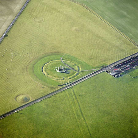
Aerial view of Stonehenge showing the stone circle, ditch and bank and the avenue cut by the road. A barrow is also visible to the left. Image ©English Heritage
Aerial photography as a means of observing archaeological sites has been appreciated since the 1850s, although the first recorded aerial shots for archaeological recording did not occur until the early 1900s when an aerial survey of the Roman port of Ostia was undertaken. These earliest aerial photos were taken from tethered balloon, box kites or scaffold towers, in the UK it was not until the extensive aerial survey undertaken in the 1940s by the RAF that planes were used. Most of the photos taken by the RAF are available to view as part of the National Monuments Record, however most, if not all of these shots were taken vertically (straight down) which is not always the best angle for the identification of archaeological remains. In fact, in the final years of WWII most intelligence units had at least one archaeologist on board to interpret aerial photos (who says archaeological training isn’t useful – we can do almost anything!).
There are three ways in which an archaeological site can be observed through aerial photography, as Shadows, crop/parch marks and as soil marks. Shadow sites Visible or known sites show up best as shadow sites and can look pretty spectacular. As the sites are already known about and sometimes have standing remains they are easy to locate for aerial survey and so photographs can be planned accordingly. Sites are best photographed at either the start or the end of the day when the sun is low and shadows are long, causing minor variations in the ground to cast long shadows highlighting details like walls and ditches. Sites that show up well as shadow sites can also be well photographed in the winter after heavy frost or light snowfall where differential melting patterns can be observed in a similar way. 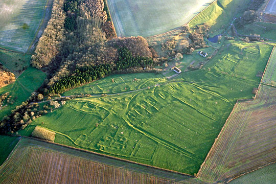
The deserted medieval village of Wharram Percy shows up well as a shadow site. Image © English Heritage
Crop/Parch Marks
Crop and/or parch marks are best seen at certain times of year. Crop marks are reliant on the growing season and can sometimes only be visible for a day or two as the crop ripens and so very careful planning is needed to obtain the aerial photographs. Crops will grow well over ditches and deep pits and are likely to be greener for longer due to moisture retention in the deeper features, over walls the crop will be shorter and may be yellow or ripe much earlier. The type of crop overlying the archaeological remains is also an important factor, cereal crops tend to highlight these changes best while crops such as beans may not show any variation in growth at all. Parch marks occur over long hot summers for similar reasons. Grass overlying walls has less soil beneath it and will dry out and turn yellow much faster than grass overlying a ditch which retains moisture. New archaeological sites are often recorded in periods of drought when swathes of green across an otherwise yellow and dry field indicate the location of old ditches. The down side to crop and parch marks is that modern drains and geological features such as gaults can also show up in this way. 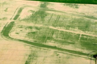
A Roman fort is visible in the green crops during a dry season in 2010. Image from a 2010 Daily Mirror article.
Soil Marks
Soil marks appear after ploughing, when the turnover of the soil reveals a contrast between the topsoil and underlying soils and anything else below. Ditches cut through a chalky geology can show up this way as can old walls, like Roman villa foundations lying just below the topsoil. Unfortunately, however, sites that show up in this way though are being eroded and a series of successive aerial photos can show how bad the erosion is. 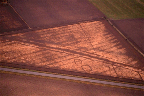
A number of features show up as soil marks in a freshly ploughed field. Image © allthingsaffs.com
How to take aerial photos Aerial photos, like all field work should be planned and systematic to ensure the best outcome. It is important to include fixed reference points in the photographs to aid with interpretation and location of features on the ground. In general archaeological shots tend to be taken at oblique angles, which may distort the image in terms of mapping, but makes the remains easier to see and interpret. Vertical shots though have their uses and are better for direct mapping of sites. Successive aerial photography sessions can also be used to monitor a site over time and English Heritage has a large bank of photos which capture changes at Stonehenge and other sites. The rise of cheap, remote control aerial vehicles with high resolution cameras – drones, has reduced the cost of aerial photography massively – no need to hire a helicopter or hope the RAF come by. As a result a number of active excavation sites now also use drones to capture overviews of complete sites and to document the excavation process. Drones can be used to great extent to either capture details of the site in complex areas, such as intercutting ditch systems, or to obtain a complete footprint of a structure, or to stitch together a large number of photos to create and orthomosaic of an entire site for publication purposes. 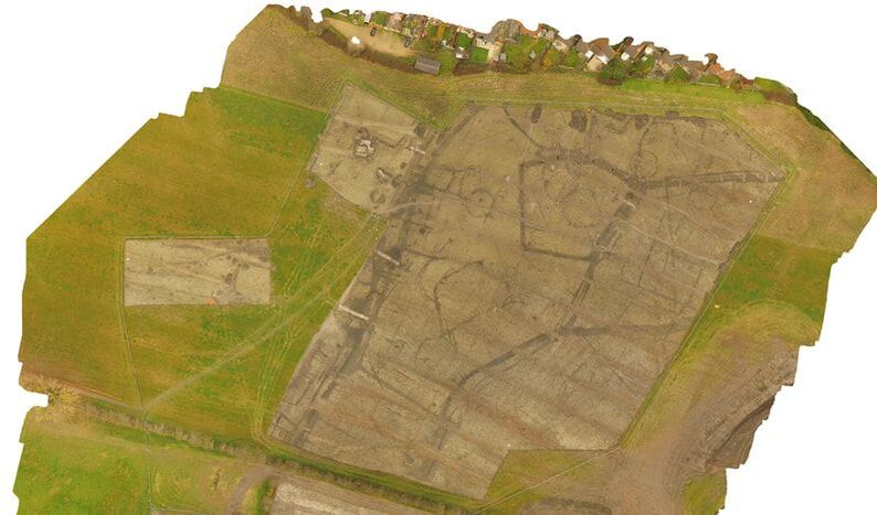
Part of a drone captured orthomosaic of one of my sites in Oxfordshire 2017 © MOLA, Image taken from the MOLA blog 'Archaeology from the air at Blaise Park' 19.2.18
Remote Sensing, Lidar and Space Archaeology New technology allows us a greater field of view in aerial photography – When I was studying, drones were a figment of the imagination, Lidar didn’t really exist, and satellites did not produce good enough photos. These new(ish) methods of aerial survey really deserve a complete blog post to themselves (which means I need to go and do some research!), but I’ll try and give a brief overview here. If anyone knows better how these new techniques work please comment and share your expertise and experience! Using photos taken by Satellites (Remote sensing) is not a completely new phenomenon although the quality of the photos has greatly improved. In 1938 Nasa worked with archaeologists to map Mayan settlements in the Yucatan using photos taken from orbiting satellites. In more recent history Space Archaeologist Sarah Parcak has been undertaking a detailed study of Egypt and to date has located 17 additional pyramids, documented a number of new settlement sites and tentatively mapped the city of Tanis (Where Indiana Jones finds the Ark in Raiders). The mapping of the city is truly amazing, although I think it came as a bit of a blow to the French team who had been carefully uncovering it for 10 years or so. However, now they can use her mapping to target their excavations and better answer archaeological questions. Lidar Lidar (Light Detection and Ranging or Laser Imaging Detection and Ranging) is a remote sensing method that uses light in the form of a pulsed laser to measure variable distances to earth. Basically, 3D laser scanning. It can be used to produce high resolution topographical maps for a whole range of purposes including archaeology. Due to its ability to map features under tree canopy and features almost indistinguishable from the ground, it has been used to great effect. In 2016 a total of 17 elevated roads were recorded during a survey of Mayan sites in Guatemala. Further use of Lidar has led to discovery and mapping of a number of Mayan settlements that were previously unknown. Aerial surveys have changed a lot in the past 20 years and as technology continues to improve and we continue to discover new sites the aerial perspective will remain important to the archaeological process. But I’m personally not going to be hanging up my trowel just yet. 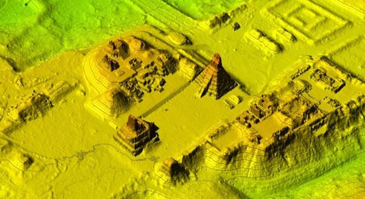
A really fantastic Lidar survey image of the Maya city of Tikal © Juan Carlos Fernandez Diaz/National Center for Airborne Laser Mapping
1 Comment
|
S. M. PorterProfessional archaeologist and author, S. M. Porter loves history, adventure and digging in the mud. Her career is in ruins - just where she wanted it to be. Archives
June 2023
Categories
All
|

 RSS Feed